I expect that many readers of the N2Africa podcaster would readily answer ‘no’ to that question. However in spite of knowing that land area estimates can be unreliable, N2Africa and other agricultural development projects often rely on estimates of plot areas, and that on top of estimates of crop yield. We may have no other choice if we want a lot of data, preferably for multiple (past) seasons, for several crops in different countries.
|
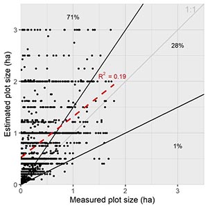
So how inaccurate are these land area estimates exactly? In the recent Impact Study, some legume plots were measured with a GPS tool – tracing the field boundaries. The area estimates by farmers were collected as well, and a comparison generates the figure below. It is a shocking graph: of all plots (1471 in total), 71% have >50% overestimation; 28% have <50% over/underestimation; and 1% of all plots have >50% underestimation. The difference between estimated and measured areas is not predictable. The figure shows that researchers should take great care with collecting and interpreting area data. |
 |
Evidently, the Impact Study data on productivity are analysed on the basis of the GPS-traced area measurements, but unfortunately not all of the legume plots were measured that way because it is a time-consuming effort. Therefore, rather than relying much on impact indicators like legume yield and legume area, other indicators like technology awareness and use receive more focus in the Impact Study analysis.
Eva Thuijsman, Wageningen University & Research, The Netherlands